Riverside Resources and Questcorp complete geophysics programs at La Union
VANCOUVER, British Columbia, July 09, 2026 (GLOBE NEWSWIRE) -- Riverside Resources Inc. (“Riverside” or the “Company”) (TSX-V: RRI) (OTCQB: RVSDF) (FSE: 5YY0) is pleased to announce, with partner Questcorp Mining Inc. (CSE: QQQ) (OTCQB: QQCMF) (FSE: D910) ("Questcorp"), the completion of expanded geophysical programs linked to the current drilling at the La Union Project, Sonora, Mexico.
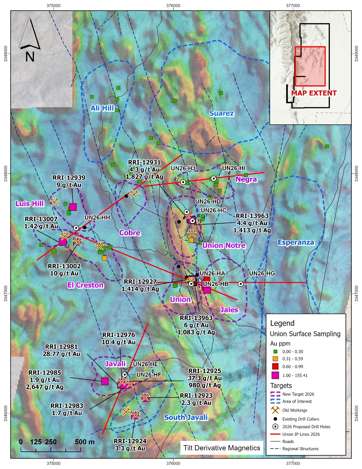
The programs included an aeromagnetic drone survey and an Induced Polarization ("IP") ground geophysics survey. The aeromagnetic survey has been completed, and the processed data has now been received and can be integrated into the ongoing summer core drilling program at La Union. The IP ground survey has also been completed, with processed results expected soon; this data will build on current drill targets and is anticipated to identify expansions and additional targets, consistent with the robust H1 2026 exploration efforts at the project.
The geophysics can potentially be applied immediately to the active drill program, which has so far focused on three areas: Union, Union North, and Jabali. The IP data covering these areas is being used to interpret results from completed drilling and to expand targets, extending the potential for drilling along strike and at depth. Initial work had generally relied on surface mapping, geochemistry, and past mine activity as a guide. This more robust and expansive geophysical dataset helps place Union's discovery potential in a larger regional context, similar to major deposits in Arizona and Sonora where these tools have proven effective at that scale.
Highlights
- IP program completed and extended over current drilling and into new mapped target areas
- Drilling completed at Union and Union North targets
- Actively drilling the Jabali target
- Aeromagnetic drone survey: The final report has been received for 145 flight lines totaling 193 km, plus 20 tie lines totaling 55 km, for 248 km of total drone coverage. The survey builds on the 2025 baseline dataset and was flown at 100 m line spacing for high-resolution definition, which now shows good targets
- Cross structures trending NE and NW potentially coincide with mapped feeder fault zones for the Carbonate Replacement Deposit (“CRD”) and sediment-hosted gold
- Relating the outcropping diorite bodies into a larger context for potential scale and their relationship to the known gold-zinc mineralized areas at Union
- Improved imaging of structures beneath post-mineral cover, including the new NW trending structures identified by spring 2026 field mapping as a potential ore control creates new targets which have never been drilled before.
"With the IP survey now complete, combined with the processed aeromagnetic data, we have a expanded view of the Union Project's targets and structural framework, both at depth and along strike from current drilling," said John-Mark Staude, President and CEO, Riverside Resources Inc. "Our teams are in the field continuing Phase 2 drilling, and this data is immediately helping us expand targeting and prioritize the project's robust set of targets. The program is going well, and our teams are processing drill core and sending samples to the laboratory for assays. We're also now using the new geophysics to put our surface geology observations into a mineralization targeting context, helping focus our efforts toward discovering high-grade gold and base metals similar to what was previously mined here, now with geophysics to help image potential source targets at depth."
pzo
News by QuoteMedia - http://www.quotemedia.com
Copyright (c) 2026 QuoteMedia, Inc.