Intercepts extracted and reviewed by Strikepoint from the issuer’s filings. True widths may differ from downhole widths; see the full release for drill orientation.
Notable Historical Mineralized Drill Intercepts at Goodrich
(TheNewswire)
Vancouver, BC, Canada – Monday, October 5, 2026 – TheNewswire - Great Plains Metals Corp.("GPS" or "the Company", TSX-V: GPS, Frankfurt Exchange: 8VC) is pleased to announce the Notable Historical Mineralized Intercepts at the Goodrich copper-gold project in New South Wales, Australia, following an extensive review of historical drilling records located in the NSW Resources archives.
Furthermore, this has proven invaluable in identifying the drill targets for the upcoming fully funded Stage 2 drill program that is scheduled to commence later this month. The Company will provide further information on the upcoming drill program in due course.
Key Highlights:
A review of over 5,000 meters of Goodrich drill records in the archives at NSW Resourcesrevealed that several holes from drill programs completed in the 1980s encountered significant porphyry-related copper-gold mineralization.
Diamond drill hole KB11 intersected 50.08 meters of 0.41% Cu and 0.32g/t Au
Diamond drill hole DDHG10 intersected 37 meters of 0.55% Cu and 0.17g/t Au
Percussion drill hole YG08 intersected 33 meters of 0.65% Cu and 1.43 g/t Au
Shallow Mineralization Identified at Surface:Multiple shallow percussion holes in the YG series starting from just 1 meter deep, highlighted by23 meters of 0.52% Cu and 0.73 g/t Au(YG07) and15 meters of 0.33% Cu and 0.84 g/t Au(YG19) at the northern margin of the historic workings.
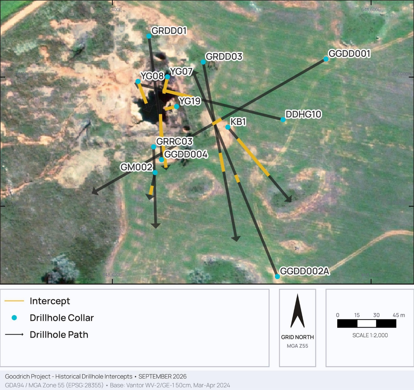
The Company was able to review data from over 5,000 meters across 46 drill holes completed at Goodrich since 1980. The key historical drillintercepts have been mapped (Figure 1) and the notable drill intercepts displayed in Table 1 below.
This newly acquired data builds upon the completed Stage 1 drill program, in particular, drillhole GGDD004 that verified a continuous, 128-meter intercept of porphyry-style mineralization of 128 meters of 0.34% copper and 0.17 g/t gold.
*Drill intercepts are reported as net mineralized downhole lengths where post-mineral barren dykes have been geometrically subtracted.
Click Image To View Full Size
Figure 1. Historical Mineralized Drill Intercepts
These legacy drill results from decades ago, further indicate that significant gold-copper mineralization is present in the Goodrich district. Fortunately, the original core, photos and assays are well preserved at the W.B. Clarke Geoscience Centre, Londonderry Drillcore Library in New South Wales and a review of this data confirmed that several Unidirectional Solidification Textures (UST) zones, a diagnostic indicator of the upper contact of a mineralized porphyry intrusion, are associated with near surface mineralized porphyry cupolas. The forthcoming drilling program is designed to test the geological relationship which will enable subsequent deeper drilling.
It was also observed from the photographic record of the core that significant intervals of hydro-thermally altered monzonite porphyry were not assayed. GPS has recently completed a sampling program and a total of 94 one meter half core slices from historic holes KB1 and DDHG10 have been submitted for assay.
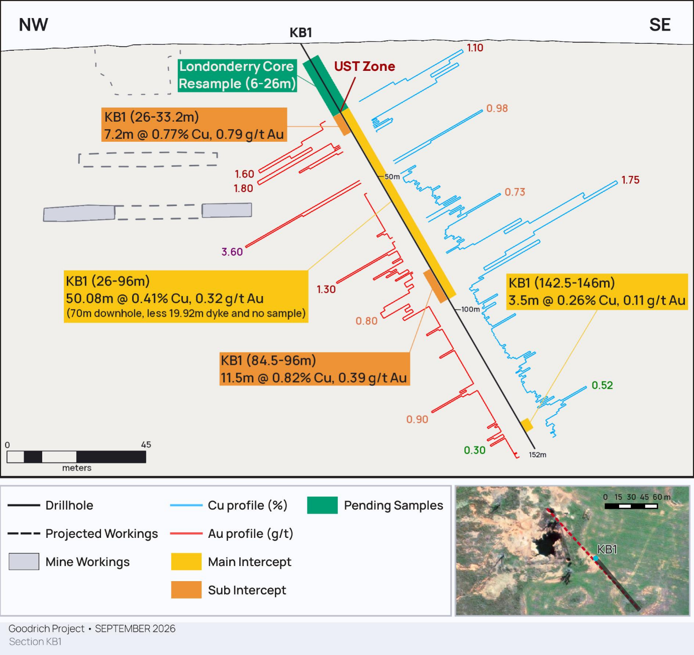
Drill hole KB1 (Geopeko Ltd, 1980) drilled in a southeast direction away from the historic mine workings, intersected several intervals of altered and mineralized monzonite porphyry as highlighted in Figure 2. Importantly, an unrecognized UST zone from 26 to 33 meters assayed 0.77% Cu and 0.79g/t Au, indicating the upper contact of a highly mineralized cupola.
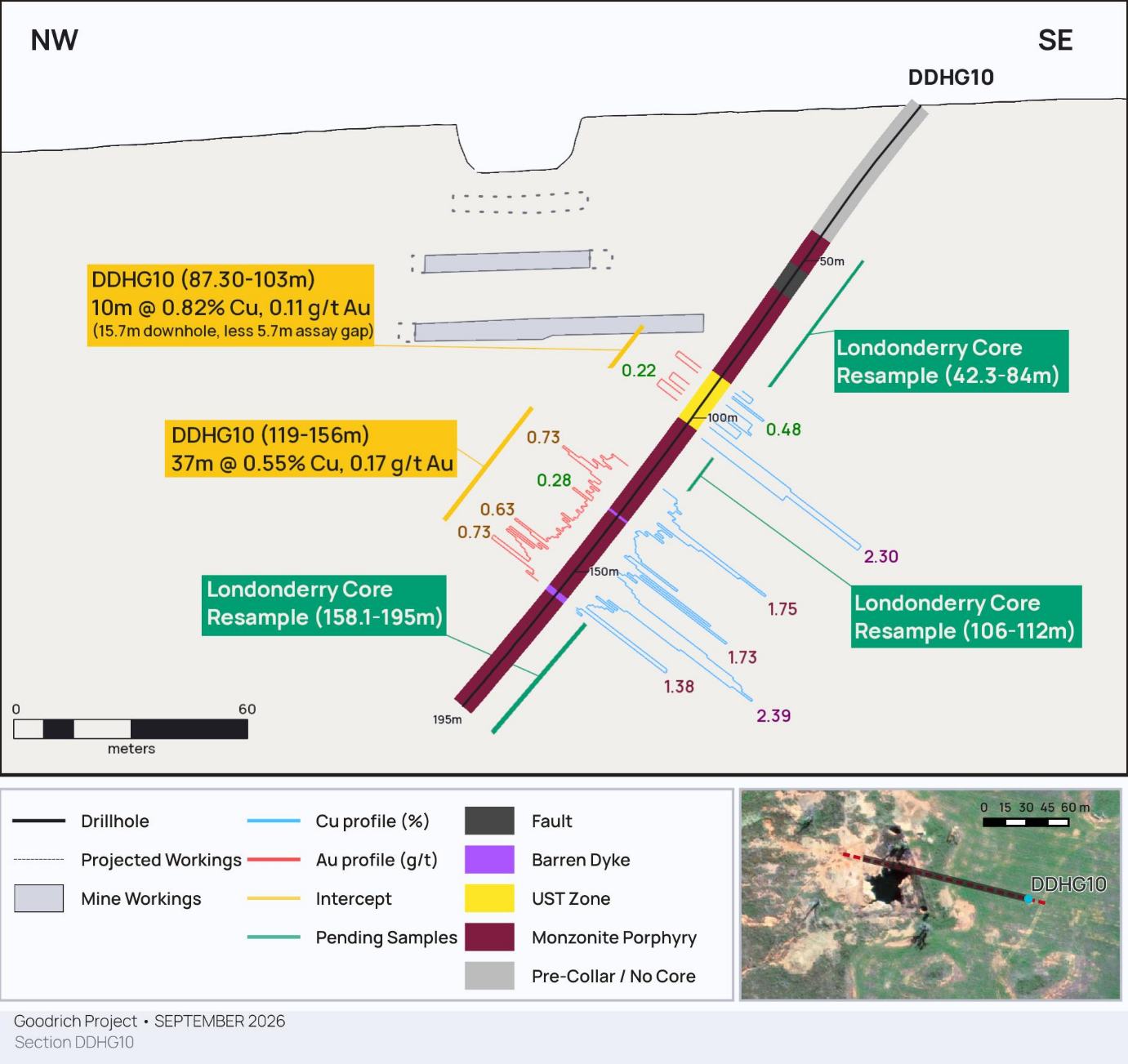
Drill hole DDHG10 (Kevin Barker, 1985)was collared to the east of the old mine and drilled back towards the workings in a north northwest direction.A thick mineralized UST zone was intersected from 87 to 103 meters with only partial historical assays that are shown in Figure 3. For unknown reasons only limited selected sampling of this hole was carried out, despite the obvious presence of altered and mineralized monzonite porphyry. Sampling was conducted from 119 to 156 meters which averaged 0.55% Cu and 0.17g/t Au.
Drillhole YG08
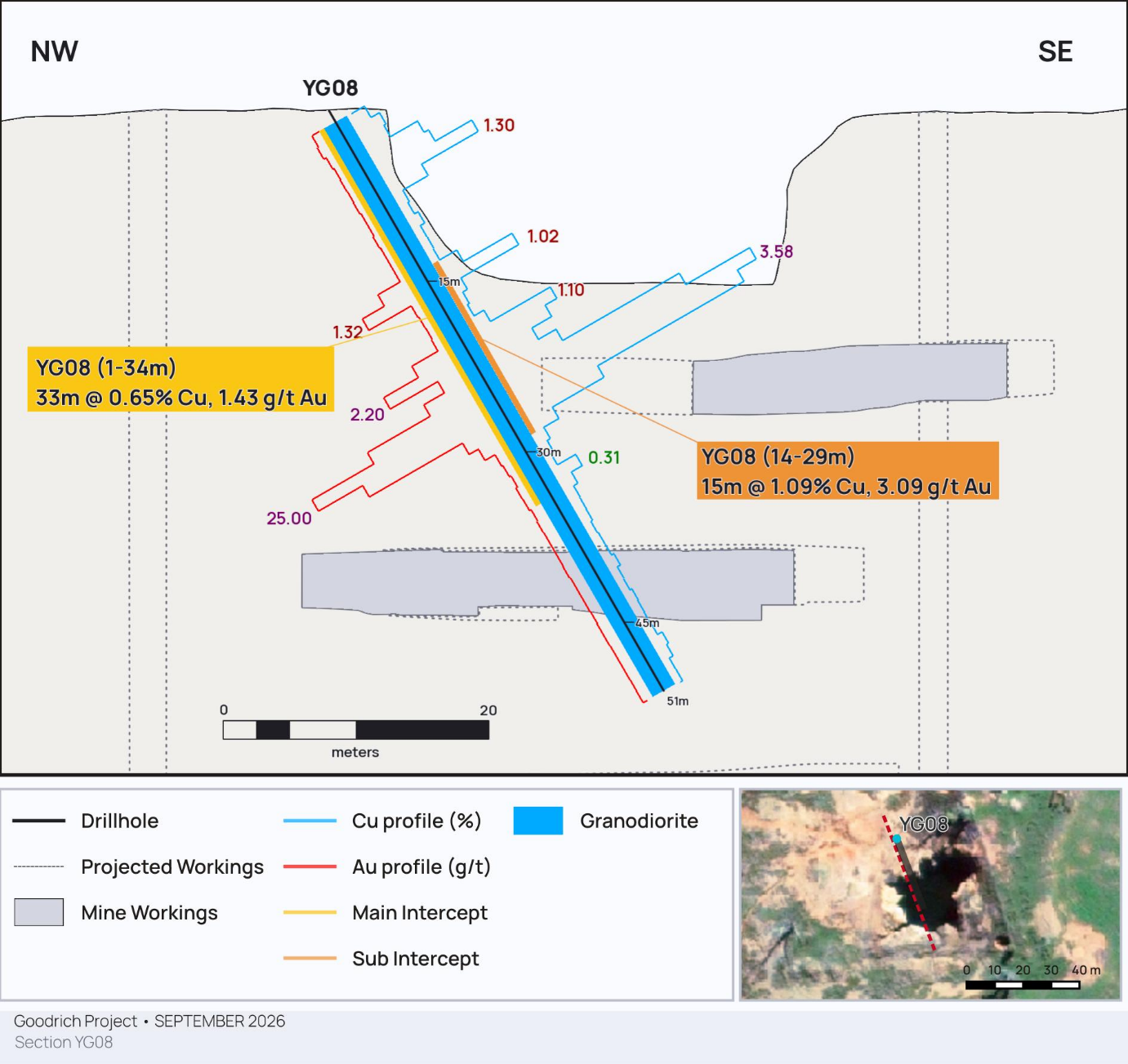
Click Image To View Full SizeFigure 4. Historical Drillhole YG08Mineralized Intersection
Percussion drill hole YG08 (Lynch Mining, 1988) was collared at the northern margin of the mine workings and was drilled to a depth of 51 meters. The 33 meter interval from 1 meter assayed 0.65% Cu and 1.43 g/t Au, which was described as altered and silicified granite with sulfides.
Importantly, YG08 is supported by several other notable shallow holes in the immediate vicinity within the YG series. This includes hole YG07, which intersected 23 meters of 0.52% Cu and 0.73 g/t Au from 1 meter, and hole YG19, which returned 15 meters of 0.33% Cu and 0.84 g/t Au from 1 meter, collectively suggesting a robust blanket of near-surface gold-copper mineralization.
The full results from all the historical drill holes that were evaluated is shown below in Table 2 with supporting drill collar information in Table 3.
Peeyush Varshney, CEO, commented:
“Today's news release highlights a pivotal milestone for GPS as we technically validate the historical foundation of our flagship Goodrich project. Decades ago, when initial drilling programs were conducted in 1980s and throughout the late 1990s, the economic reality of the copper market was vastly different. In those price environments, the robust intervals encountered, such as 50.08 meters of 0.41% copper and 0.32 g/t gold in hole KB1, were routinely overlooked as exploration priorities shifted during periods of depressed commodity prices.
Today, the global landscape has completely transformed. Driven by electrification, AI infrastructure and the green energy transition, the mining industry is facing a severe reality of depleting high-grade resources. According to industry data from Mining Intelligence, the average copper grade for producing mines worldwide has fallen to approximately 0.53% [1], while the average grade for upcoming projects in development has dropped even lower to just 0.39% [2].
Additionally, the historical data from the shallow YG series provides important structural context for the upper zones of the deposit. Encountering near-surface mineralization starting from 1 meter deep, highlighted by the main intercept of 33 meters of 0.65% copper and 1.43 g/t gold in hole YG08, which includes a higher-grade core of 15 meters of 1.09% copper and 3.09 g/t gold from 14 meters,indicates that copper-gold mineralization extends to the surface at the northern margin of the historical workings.
Furthermore, within the porphyry system that has been recognized at Goodrich, looking at the copper grade in isolation only tells half the story. The associated gold content is also a key economic driver and can transform project economics.
Against this backdrop, data we have unlocked from the NSW Resources archives with mineralized intercepts that were ignored forty years ago provide further evidence that a robust porphyry system exists beneath the old Goodrich Mine workings."
Table 2: Full Historical Drill Hole Results
Drill Hole ID
From (m)
Interval (m)*
Copper (% Cu)
Gold (g/t)
Comments
DDHG3
Not assayed
DDHG4
30.49m
15.30m
0.1%
0.32 g/t
DDHG5
No significant intercept
DDHG6
Not assayed. No mineralization.
DDHG7
Not assayed. No mineralization.
DDHG10
87.3m
10m
0.82%
0.11 g/t
Partial assays: 5.7 meters missing assays
DDHG10
119m
37m
0.55%
0.17 g/t
GGDD001
152m
86.80m
0.14%
0.16 g/t
91m downhole less 4.2m dyke
including
152m
9m
0.72%
0.71 g/t
including
216m
13.8m
0.27%
0.39 g/t
17m downhole less 3.2m dyke
GGDD002
Abandoned at 16.2m. Not assayed.
GGDD002A
57.86m
77.43m
0.1%
0.13 g/t
79.14m downhole less 1.71m dyke
including
79m
7m
0.21%
0.32 g/t
including
131m
6m
0.32%
0.36 g/t
GM001
No significant intercept.
GM002
88m
84m
0.2%
0.13 g/t
including
112m
12m
0.54%
0.33 g/t
including
144m
12m
0.31%
0.24 g/t
GRDD01
146m
48m
0.33%
0.23 g/t
57m downhole less 9m dyke
including
158m
4m
0.31%
0.24 g/t
including
166m
28m
0.47%
0.33 g/t
37m downhole less 9m dyke
GRDD02
125m
6m
0.35%
0.17 g/t
GRDD03
74m
15m
0.2%
16m downhole less 1m dyke
GRDD03
109m
6m
0.21%
GRDD03
131m
19m
0.47%
0.15 g/t
22m downhole less 3m dyke
GRDD03
202m
6m
0.15%
0.13 g/t
GRDD03
247m
2m
0.34%
0.3 g/t
GRDD04
No significant intercept
GRDD05
No significant intercept
GRDD06
121m
7m
0.22%
0.08 g/t
GRDD06
158m
3m
0.44%
0.08 g/t
GRDD07
No significant intercept
GRCC01
No significant intercept
GRCC02
No significant intercept
GRCC03
117m
27m
0.15%
0.21 g/t
GRCC04
No significant intercept
GRCC05
No significant intercept
GRCC06
No significant intercept
GRCC08
Not assayed.
GRCC09
Not assayed.
GRCC10
Not assayed.
GZ01
No mineralization. Not assayed.
KB1
26m
50.08m
0.41%
0.32 g/t
70m downhole less 19.92m dyke
including
26m
7.2m
0.77%
0.79 g/t
including
84.5m
11.5m
0.82%
0.39 g/t
KB1
142.5m
3.5m
0.26%
0.11 g/t
YG01
14m
6.5m
0.56%
0.22 g/t
YG03
1m
4m
0.33%
0.03 g/t
YG04
No significant intercept
YG05
No significant intercept
YG06
No significant intercept
YG07
1m
23m
0.52%
0.73g/t
YG08
1m
33m
0.65%
1.43 g/t
including
14m
15m
1.09%
3.09 g/t
YG09
1m
17.5m
0.39%
0.47 g/t
YG12
No significant intercept
YG13
No significant intercept
YG14
No significant intercept
YG15
No significant intercept
YG16
No significant intercept
YG17
No significant intercept
YG18
No significant intercept
YG19
1m
15m
0.33%
0.84 g/t
YG20
81m
9m
0.4%
0.04 g/t
10m downhole less 1m dyke
*Drill intercepts are reported as net mineralized downhole lengths where post-mineral barren dykes have been geometrically subtracted.
Table 3: Drill Hole Collar Information
Drill Hole ID
Easting
Northing
Elevation (m)
Azimuth (°)
Dip (°)
Total Depth (m)
GGDD001
648,565
6,373,014
459
235
-55
335.96
GGDD002
648,526
6,372,848
453
335
-55
16.2
GGDD002A
648,527
6,372,845
453
335
-55
282.6
GZ01
648,199
6,372,700
438
180
-60
240
GM001
648,460
6,372,855
448
157
-60
154
GM002
648,432
6,372,926
450
194
-84
208
GRCC08
648,253
6,372,824
437
218
-60
96
GRCC09
648,713
6,372,694
448
180
-60
54
GRCC10
648,793
6,373,124
463
180
-60
78
GRDD05
648,428
6,373,127
456
180
-57
300.2
GRDD06
648,513
6,373,053
460
180
-53
162
GRDD07
648,388
6,373,099
455
180
-54
336.75
GRDD01
648,428
6,373,031
458
168
-60
209.8
GRDD02
648,471
6,373,015
458
213
-60
143.8
GRDD03
648,470
6,373,011
458
168
-55
254.60
GRDD04
648,347
6,372,939
454
179
-70
221.90
GRCC01
648,493
6,373,059
460
270
-60
100
GRCC02
648,443
6,373,059
459
270
-55
100
GRCC03
648,431
6,372,945
457
179
-65
150
GRCC04
648,812
6,372,984
460
270
-60
54
GRCC05
648,652
6,372,784
450
270
-50
100
GRCC06
648,493
6,372,834
452
270
-55
95
YG20
648,372
6,373,005
448
156
-68
111
YG01
648,428
6,372,946
450
12
-60
20.5
YG03
648,405
6,372,972
450
192
-60
30
YG04
648,453
6,372,961
451
192
-60
18
YG05
648,465
6,372,984
453
247
-60
25
YG06
648,453
6,372,979
452
247
-60
19.5
YG07
648,442
6,373,000
452
192
-60
24
YG08
648,419
6,372,996
451
159
-60
51
YG09
648,408
6,372,983
450
129
-60
18.5
YG12
648,520
6,372,946
454
192
-60
25
YG13
648,520
6,372,938
454
192
-60
35
YG14
648,474
6,372,896
450
327
-60
24
YG15
648,484
6,372,903
451
237
-60
25
YG16
648,486
6,372,904
451
158
-60
25
YG17
648,547
6,372,888
453
237
-60
25
YG18
648,451
6,372,952
451
192
-60
25
YG19
648,449
6,372,977
452
257
-60
16
DDHG10
648,531
6,372,967
455
282
-50
195
DDHG6
647,943
6,373,260
441
missing
-60
39
DDHG7
647,944
6,373,265
441
missing
-60
39
DDHG3
648,535
6,372,943
455
missing
missing
65
DDHG4
648,560
6,372,881
453
282
-60
200.4
DDHG5
647,673
6,373,024
426
2
-60
110.4
KB1
648,489
6,372,961
453
140
-60
152
Coordinate datum/projection: GDA94 MGA Zone 55
Quality Control & Quality Assurance
Historical drill results reported in Table 2 and Table 3 were sourced from the archives held by NSW Resources, a division of the Department of Primary Industries and Regional Development (DPIRD). These legacy results span multiple generations of exploration campaigns conducted at the Goodrich Project by separate operators prior to the adoption of current industry-standard QA/QC protocols.
To ensure transparent verification under modern reporting frameworks, the 43 historical holes evaluated from the public database are grouped into the following historical campaigns:
The Geopeko Ltd Campaign (1980): Includes diamond drill hole KB1. No laboratory assay certificate or explicit analytical methodologies have survived in the public archive for this specific hole.
The Kevin Barker Lynch Mining Campaigns (1984–1990): Includes the DDHG series (DDHG3, DDHG4, DDHG5, DDHG6, DDHG7, DDHG10) and the YG percussion series (YG01, YG03 through YG09, and YG12 through YG20). Verified copies of original laboratory certificates were recovered and reviewed for holes DDHG10 (assayed at ALS Orange via methods Au-PM209 and G001) and for all YG holes. The 1988 holes (YG01 through YG19) were assayed at Australian Assay Laboratories Group via methods D610 and D100, and YG20 was assayed at ALS Orange via methods PM203 and G001. Data for the remaining DDHG holes are derived from historical compilation logs and have unverified certificate lineages.
The Malachite Resources NL Campaigns (1998-2002): Includes the GRDD diamond series (GRDD01 through GRDD07) and the GRRC reverse circulation series (GRRC01 through GRRC06, and GRRC08 through GRRC10). Original lab certificates for these programs were not located; however, historical data logs note that samples from all assayed holes were processed by ALS utilizing Au-PM209 and ME-IC581 methods. GRRC08 through GRRC10, drilled in 2002, were not assayed.
The Augur Resources Ltd Campaign (2010): Includes reverse circulation holes GM001 and GM002 which were assayed by ALS via methods Au-AA26 and ME-ICP41. Standalone certificates for these holes are currently missing, however, job tracking numbers are verified via archive summaries.
The Zodiac Resources Pty Ltd Campaign (2012): Includes reverse circulation hole GZ01, drilled under a farm-in agreement with Augur Resources Ltd. GZ01 was not assayed due to a lack of observed mineralization.
In addition, the Godolphin Resources Ltd Campaign (2023) includes diamond drill holes GGDD001, GGDD002, and GGDD002A. GGDD002 was abandoned at 16.2m and not assayed. Original laboratory certificates were obtained and reviewed for holes GGDD001 and GGDD002A, prepared at ALS Orange and assayed at ALS Perth via methods Au-ICP21, ME-MS61, and Cu-OG62. Certified reference materials and blanks were inserted at approximately one in every 20 samples.
Qualified Person Statement
Mr. Douglas Kirwin, an executive Director of Great Plains Metals Corp and a non-independent Qualified Person (QP) as defined by National Instrument 43-101, has comprehensively reviewed the historical compilations, geological logs, available laboratory certificates, and drill core photographs available within the state database. Mr. Kirwin cautions that the historical results have not been independently validated to modern standards and should not be relied upon as confirmed resource grades. Data verification is currently being conducted by the Company through the confirmatory resampling program described below. They are, however, considered a reasonable and reliable basis for exploration targeting.
To independently validate these legacy records and rectify gaps in the historical assay streams, the Company has undertaken a confirmatory resampling program of drill core archived at the W.B. Clarke Geoscience Centre, Londonderry Drillcore Library. A total of 94 half-core samples across key intervals in KB1 and DDHG10 have been submitted to Australian Laboratory Services Pty. Ltd. in Orange, NSW, which is independent of the Company and accredited to NATA standards for analysis via fire assay with AAS finish for gold and four-acid ICP-AES for multi-element suites.
About Great Plains Metals Corp
Great Plains Metals Corp is an emerging, Australia-focused exploration company targeting copper-gold porphyry and district-scale critical mineral discoveries. The Company’s fast-track discovery strategy centers on technically validating high-grade, drill-ready targets situated within premier geological jurisdictions.
The Flagship Goodrich Project (NSW): Located in the heart of New South Wales' premier copper-gold jurisdiction – near the Yeoval township and roughly 70 km northwest of Orange – the project spans an extensive 290 km² across exploration licenses EL9243 and EL8538. The Goodrich Project is situated within the world-class Lachlan Fold Belt.
Proven Mineral Footprint: Historically the largest mine in the Yeoval district, Goodrich operated intermittently between 1868 and 1912. Production from its historic 46 meter open pit and 90 meter underground shafts yielded an estimated ~300 tonnes of copper, 159 kg of gold, and 62 kg of silver, notably supporting a local smelter facility during its peak operational phases. Modern geological modeling suggests this historical mining merely exposed the upper tip of a significantly larger, robust porphyry core system below the old mine.
Strategic District-Scale Upside: GPS holds a 37.1% equity stake in Eversley Resources, giving the Company low-cost exposure to the Eversley North Gawler Craton Project in South Australia. Spanning an extensive 2,584 km² within the prolific Olympic Dam IOCG province, the project targets shallow, high-intensity Iron Oxide Copper-Gold (IOCG) systems alongside a near-surface Ionic Clay Rare Earth Element (REE) prospect. With a Native Title Mining Agreement for Exploration secured and target depths uniquely shallow at under 150 meters, the project represents immediate, high-value asset diversification.
[1] McCrae, M. A. (2018). Early stage copper projects have grades one-third below operating mines. MINING.COM / Mining Intelligence. Available online via MINING.COM.
[2] Stockhead Resources. (2022). EXPLAINER: How drilling results make the grade — Copper and Zinc. Stockhead Market Analysis. Available online via Stockhead.
This news release contains certain statements that may be deemed “forward-looking statements.” Forward-looking statements are statements that are not historical facts and are generally, but not always, identified by the words “expects”, “plans”, “anticipates”, “believes”, “intends”, “estimates”, “projects”, “potential” and similar expressions, or that events or conditions “will”, “would”, “may”, “could” or “should” occur. Although the Company believes the expectations expressed in such forward-looking statements are based on reasonable assumptions, such statements are not guarantees of future performance and actual results or realities may differ materially from those in forward looking statements. Forward looking statements are based on the beliefs, estimates and opinions of the Company’s management on the date the statements are made. Except as required by law, the Company undertakes no obligation to update these forward-looking statements in the event that management’s beliefs, estimates or opinions, or other factors, should change.
Neither the TSX Venture Exchange nor its Regulation Services Provider (as that term is defined in the policies of the TSX Venture Exchange) accepts responsibility for the adequacy or accuracy of this press release.
1 No laboratory assay certificate or stated analytical method has been located for KB1; see Quality Control & Quality Assurance.
Copyright (c) 2026 TheNewswire - All rights reserved.